Sun, Aug 2 Today
25° 14°
Wind 15 km/h
Precipitation 0 mm
Snowfall 0 cm
November 29, 2025
April 6, 2026
61.00€
Weather
25° 14°
23° 15°
21° 12°
23° 14°
18° 13°
18° 12°
13° 9°
Source: Open-Meteo
🏔️ History
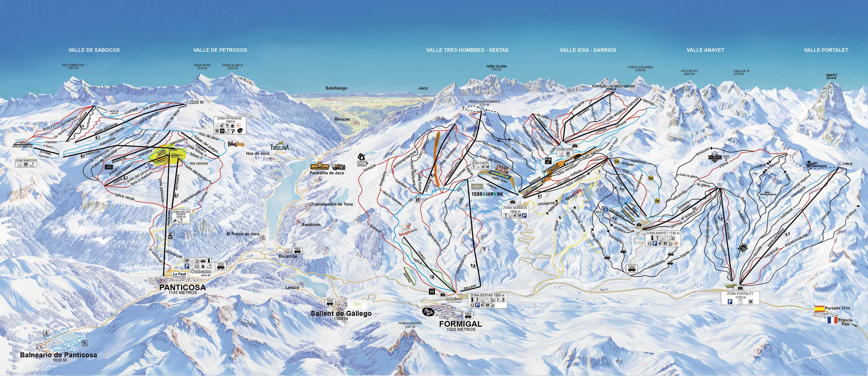
The merger of historic Formigal (opened in 1964) and Panticosa created the largest ski domain in the Aragonese Pyrenees, boasting nearly 180 km of slopes spread across four valleys (Tres Hombres, Izas, Anayet, and Portalet). Its rapid modernization and imposing scenery, dominated by the Anayet peak, have made it a major economic and tourist engine for the Tena Valley.
☀️ Best days
Cold, mid-winter weekdays. The sheer size of the resort truly shines without the crowds. Touring Formigal's four valleys under the sun with perfect snow conditions, and hopping over to the Panticosa sector to ski among the trees, is one of the most complete experiences in the Iberian Peninsula.
🚫 Days to avoid
Long holiday weekends and peak season weekends. Its enormous popularity, coupled with its famous après-ski scene, attracts thousands of visitors, leading to significant queues at the main lifts and traffic jams on the access road from Biescas.
💡 Community tip
To avoid morning bottlenecks, don't park at the main Sextas base. Keep driving up to the Anayet or Portalet parking lots; you'll get on the snow much faster and start your day with better snow quality. And don't leave without experiencing "Marchica," the undisputed temple of après-ski in Spain.
🚗 Main access: From Huesca and Zaragoza, take the A-23 motorway to Sabiñánigo. From there, turn onto the N-260 and then the A-136, which heads up the spectacular Tena Valley towards the French border (Portalet pass). Halfway up, you'll find the turnoff for Panticosa; continuing on the A-136 will take you to the main Formigal village.
⚠️ Winter driving: The A-136 is a wide, well-maintained road designed to handle heavy ski traffic. It is usually kept very clear by snowplows, but on the final stretch towards Formigal and Portalet, heavy snow is common. Carrying snow chains in your trunk is required by law in winter.
💡 Formigal vs Panticosa: With a single ski pass, you get access to both valleys (connected by a free 15-minute "Ski-Bus"). Formigal is huge (137 km), geared towards young people, and famous for its legendary après-ski venue ("Marchica"). Panticosa is much smaller (39 km), surrounded by rugged alpine scenery, less crowded, and ideal for quiet skiing or families.
1 cameras available