Sat, Aug 1 Today

13° 4°
Wind 26 km/h
Precipitation 0 mm
Snowfall 0 cm
November 27, 2025
April 12, 2026
Not enough reviews to compute scores yet.
139.00CAD
≈ 139€
Weather
13° 4°
16° 6°
23° 3°
27° 6°
29° 8°
30° 9°
26° 9°
Source: Open-Meteo
🏔️ History
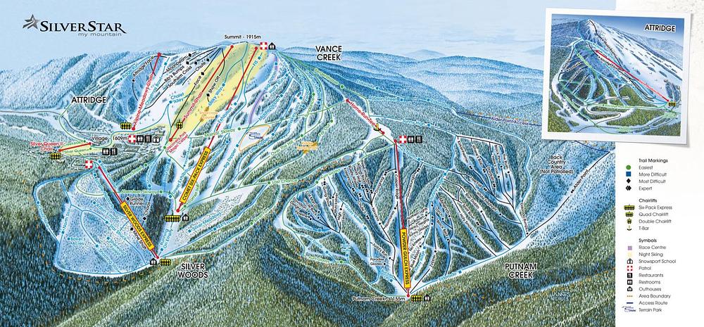
Opened in 1958, SilverStar is set above British Columbia's Okanagan Valley. It is historically famous for its unique, colorful 19th-century Victorian village, built to resemble an old gold-rush mining town. The mountain features a distinct layout, divided between friendly cruisers on the Vance Creek front side and steep, technical chutes in the Putnam Creek back side.
☀️ Best days
Mid-week days in January and February deliver exceptionally dry and light Okanagan powder. Sunny mornings are perfect for cruising the front side slopes.
🚫 Days to avoid
Peak winter weekends and days with extreme Arctic cold snaps, which can trigger partial lift closures on the upper mountain.
💡 Community tip
Advanced skiers should head straight to the Putnam Creek backside sector, which features steep black diamond runs and technical tree glades with virtually no lift lines.
🚗 Mountain road climb: From the town of Vernon, drive northeast on Silver Star Road for 14 miles (22 km). The road climbs over 3,900 ft (1,200 m) in elevation and is steep and winding; winter tires are mandatory.
💡 Park at Putnam Creek for steep backside runs: If you are an advanced skier, parking at the Putnam Creek lot allows you to access the steep black diamond backside slopes directly, bypassing the main village base crowds.

